Project — www.facebook.com/MillerCreekWQIProject
|
Location
Click Icon to Show on Map
|
City & Country |
|---|---|
|
,
|
()
|
| Countries: | United States of America |
|---|---|
| Basins: | Mississippi (419) |
|
Project SDGs:
Includes Sustainable Development Goals from the project and its locations.
|
Sustainable Agriculture (SDG 2.4) |
|
Project Tags:
Includes tags from the project and its
locations.
|
Soil Erosion and Health
Conservation Agriculture/Agronomy Groundwater |
| Services Needed: |
Policy advocacy
Communications & outreach Research & analysis Technical assistance |
| Desired Partners: |
Academic Institution
Business Business Association City Government Financial Institution |
| Language: | English |
| Start & End Dates: | Jan. 01, 2014 » Dec. 31, 2016 |
| Project Website: | www.facebook.com/MillerCreekWQIProject |
| Project Source: | User |
| Profile Completion: | 69% |
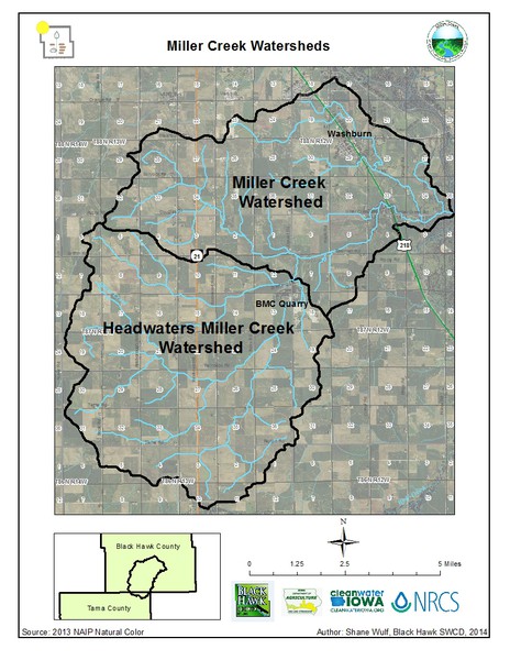
The Miller Creek Water Quality Improvement Project, led by Black Hawk SWCD, targets both the Miller Creek watershed (HUC-12 070802050905) and the Headwaters Miller Creek watershed (HUC-12 070802050904), two of Black Hawk County's most intensely farmed watersheds. Taken together, these watersheds represent over 66 square miles or 42,000 acres in south-central Black Hawk and north-eastern Tama Counties. Through the course of the three-year project, which began in January 2014,…

Shane Wulf
Watershed Project Coordinator
Iowa Department of Agriculture and Land Stewardship (Organization)
In 2013, the Iowa Department of Agriculture and Land Stewardship (IDALS) established the Iowa Water Quality Inititative (WQI) to begin implementation efforts of the Iowa Nutrient Reduction Strategy (NRS). Learn More
 Loading Lessons